The Cascade Pass trail offers an unforgettable hike for visitors to the North Cascade National Park.
Although the trailhead is more than an hour from 'anywhere' it is unquestionably well worth the time to get there; provided that the weather is decent and the road isn't blocked by snow.
Offering easy access to alpine terrain and being a main access point for longer hikes/backpack trips to Sahale Arm and Stehekin (to name just a few), the parking lot is almost always full on weekends. Consider planning your itinerary to arrive by 9:00 a.m. during peak hiking season.
To reach the trailhead, follow Hwy 20 to Marblemount (about one hour from I-5) and then drive for about another hour along the Cascade River Road to the trail head at the end of the road. The Cascade River road is about 23 miles long and only the first 10 miles or so are paved. The gravel portions are generally in pretty good shape and passable by most cars.
Scenic vistas abound, even from the parking lot. To the northeast you can look up and see Cascade Pass. The 'bad news', if such a thing exists out here, is that the trail takes a much less direct route than what you see.
The trail starts out in the forest shade, steadily climbing a reasonable grade up the hillside. Savor the gradual incline, enjoy the smaller micro-views that the forest affords you. After all, how often do you find yourself in such an area with the opportunity to stop and smell the roses (or moss, or the corn lilies)?
The route is easy to follow but the route also has its fair share of rocks, roots, 'water features' and obstacles to keep you on your toes.
Stop at the 'open' switchback and peek over the nearby rocks to get a view of Soldier Boy Falls before you finish up the last of the switchbacks.
Depending on how early or late in the season you visit, expect to run into some snow.
During our hike on 7-14-2012, we started to encounter snow across the trail just a few minutes after the falls mentioned above.
The patches at that time were relatively short and it was pretty easy to see where the trail was supposed to go and it was possible to follow that route on top of the snow and emerge back onto real ground just 10, 20 or 30 yards away.
Keep in mind that snow crossings can be hazardous. It's easy to accidently slip and injure yourself. This is not the place you want to find yourself injured. Pack accordingly... wear shoes/boots with good traction, bring traction devices with you (such as yaktrax or microspikes), bring hiking pole(s) or an ice axe if you can.
Better safe than sorry.
Eventually, the switchbacks end and you find youself heading out into the open 'meadows'. Some grass, heather, flowers... but also lots of rocks, talus and boulders. Plus at least two more snow crossings with long runouts if you happen to slip and fail to self-arrest your slide.
We happened to encounter a deer at this point in the trail. It came walking right up to us on the trail as if it had already visited Cascade Pass today.
Once it was within arms reach, it decided to take a minor detour around us, then came back to see if we had any treats. We didn't and it continued to proceed toward the trail head and the group of hikers behind us.
Finally, we were almost to Cascade Pass. You can see the trail crossing one of the snow fields in the distance.
We were greeted at the Pass by a Ranger (who has the best job in the world IMO). We took a break on the granite blocks and enjoyed a casual lunch and many photo opps.
I call it "North Cascades Happy".
Since there was more snow than we had anticipated, we chose to make Cascade Pass our turn-around spot instead of continuing up to/toward Sahale Arm.
If you happen to have the time and energy, hiking the extra distance and elevation to Sahale Arm is highly recommended.
The route back to the trail head is the same as the ascent, but downhill.
We happened upon a Hoary Marmot who is pursuing a career in modeling.
We hadn't seen too many hikers on our way up, but it turns out that we were just ahead of the crowd. There were plenty of people on their way up as we descended the switchbacks. Everyone was smiling. :)
A HUGE Thank You to the France Family who braved the ever-changing weather forecast to participate in this unforgetable hike. It's always a pleasure to hike with you all!
For those of you that happened to have seen my recent posts related to my hike with Steve G. to Goat Lake (report here), you may have seen my first experiment with creating an abbreviated 'trail specific' hike overview / Trail Journal (link here).
Well, with all the fantastic images from this hike, plus the popularity of the destination, you probably won't be surprised to find out that I've created a similar composition for Cascade Pass.
Here is a Book Preview of all the pages (there are only 20 pages and at least 17 of them are AWESOME)! Check it out and let me know what you think. Seriously.
I know these are expensive (especially when you tack on shipping), but I'm hoping to come up with an alternative (cheaper) variation before the 2013 hiking season arrives. Any constructive advice would honestly be appreciated.
In the meantime, Happy Hiking!
~E
Friday, July 27, 2012
Wednesday, July 18, 2012
Goat Lake, THE BOOK!
The above image should provide you access to my new book that came about based on info and images from my recent trip to Goat Lake with Steve G. There should be softcover (recommended) and hardcover versions available, plus an ebook that is compatible for iphones and ipads.
What is unique about this book is that it contains a number of blank/lined journal pages at the end where owners/hikers can record their own musings or whatnot to memorialize or share their own experiences. They can keep it... or share it with others.
Sure, waterproof paper would be nice, but that's not an option via blurb, yet.
I'm honestly interested in your opinions on how this turned out. Admittedly, some parts turned out better than others, but everyone starts somewhere. :)
If the above link doesn't work as designed, try finding the Goat Lake book in my Blurb Bookstore via this link.
Click here for the link to the Goat Lake trip report from June 23, 2012.
Happy Hiking!
~E
Monday, July 16, 2012
Goat Lake (MLH) 06-23-2012
Goat Lake is a beautiful lake located in a large glacial cirque in what was once a popular mining area.
Located along the Mountain Loop Highway, between Granite Falls and Darrington, the trail to Goat Lake is about a 10 mile round trip adventure with relatively mild elevation gain (1,700 feet of elevation gain and about 10 or 11 miles round trip).
Despite the fact that I've been actively hiking for about 10 years, Goat Lake never came onto my radar screen until just this last spring when discussions started popping up on Facebook and nwhikers.net. Then it was publicized as one of WTA's "Featured Hikes".
Generally speaking, my hiking preferences center around big views and elevation gain... leaving the "Lake Focused" hikes for days that are forecasted to be wet or less than ideal for big view destinations.
Such was the case for June 23, 2012. The weather was forecasted to include rain... possibly a lot of it. Conflicting with the rain, rain, rain promised on TV, my super secret precipitation forecaster was suggesting that it wouldn't really be that bad. Regardless, that's what Rain Gear is for.
It turns out that 1) it's a good idea to bring your rain gear when it might rain and 2) it's a good idea to keep your raingear properly maintained so it does what it is supposed to do.
Steve G. and I connected at the Red Apple Market in Granite Falls and carpooled to the trailhead without incident. Little did we know that the sights would be a bit different on the return trip.
We were a little concerned about the recent popularity of this hike... would there be enough parking? Would it be as popular as Mt. Si? Yes, and no. Yes we found a parkign spot and no, it wasn't as crowded as Mt. Si, but it certainly wasn't solitude either.
Shortly after embarking on the trail, hikers are faced with a choice: take the upper trail or the lower trail. Both join back together before switchbacking up a slope to the lake.
The upper trail follows an old logging or mining road. The tread is pretty solid and there are a couple of nice 'water features' along the way. The upper route is also a bit longer than the lower route.
The lower trail follows alongside Elliot Creek. Very nice creek views along the way, but the trail also has a number of short ups and downs, plus quite a few muddy sections and tree roots.
First time visitors should consider a counter-clockwise loop, taking the lower trail on the way to the lake and the upper trail on the way back. Doing so allows you an opportunity to view a wider variety of trail scenes.
In the event that rain is forecasted (or it has recently rained or is currently raining), it may be prudent to skip the lower trail route. Adding more water to the mud we encountered could quickly turn a muddy trail into a hiking disaster with boots full of water and possibly making the route difficult to follow.
We chose to do the counter clockwise loop and we are glad we did.
Upon our arrival at the lake we quickly found a nice log to relax on with a view of the entire lake.
At 12:30, with blue skies above, we began to pack up and prepare for our hike out. At that point in time, rain began to fall. It wasn't a downpour but it was more than a sprinkle. We searched for a rainbow without success. Made the raingear handy and followed the trail into the woods to descend the switchbacks. The rain subsided, blue sky became even more prevalent and we incorrectly concluded that we had lucked out and were in the clear for a dry hike to the car.
A few water crossings and waterfall photos later and suddenly, within a matter of two minutes or less, the wind was screaming through the trees at highway speeds.
We quickly bagged our electronics and put on rain coats. A minute later we dropped everything and put on every piece of raingear that we owned... and it wasn't a moment too soon.
What followed was the wildest weather I have ever seen. Wind, Rain, Lightning, Thunder, Hail... Mother Nature threw the book at us! Before we knew it the trail was virtually underwater. I prayed for anyone on the lower trail... heaven help them!
The wind, lighting, thunder and hail only lasted between 15 and 30 minutes (PTL!) but the rain continued its heavy pace throughout our final 3 miles to the car.
Gear Tip: In the unlikely case where you are wearing a raincoat with a hood but decide that you'll use a separate hat instead of the attached hood, beware that it is very likely your unused hood will be filling up with rain water and beware that it will just sit in there, waiting quietly, until you decide to bend forward to check your shoelaces or to inspect something on the ground. At that point in time your hood will release a gallon of water over your neck and immediatly soak you as if you didn't own a speck of rain gear. Consider yourself warned. Steve's suggestion is to wear the hood AND the desired hat. Thanks Steve.
While we survived this squall unharmed, it turned out that others weren't so lucky. We learned that trees were down all over the place. Hikers were trapped on the Big Four Ice Caves trail. Cars were trapped on numerous roads. Two cars had trees fall on them at the Heather Lake Trailhead. Trees were down all along the Mountain loop Highway. Power was out. Power lines were down... everywhere.
On our return to Granite Falls the damage was unbelievable. Many of the downed trees had already been cut and moved to the side of the road, but one tree required us to drive around it... and over a half dozen power lines.
Our safe passage was a miracle... and an event I won't soon forget.
All in all, this was a really nice hike... for rainy weather and also for sunny weather.
There are a number of camping spots up at the lake - and I suspect most of them were being used the weekend we visited... hopefully all of those campers survived the storm without a problem.
The road to the Goat Lake trail head is located north of Barlow Pass along the Mountain Loop Highway. Since the "Loop" has been more closed than open over the last few years (due to snow in the winter and a lack of funding for road repairs) it isn't always easy to reach the trailhead.
At this point in time, the MLH and the Goat Lake road are both in good condition.
I highly recommend this hike; that's saying a lot from someone who isn't generally fond of Lake based destinations.
***UPDATE: Just finished my first impromptu Trail Guide project based on Goat Lake. It's now available via www.blurb.com, but you can also read about it and preview some of the pages right from the Big Rock Excursions blog. Click HERE to take a look...
Happy Hiking!
Friday, July 13, 2012
Itinerary for 07/14/2012
Sure... for once I know exactly where I'm going to hike, the weather is perfect (thus the chosen destination) AND I have buddies to share the day with.
Then... Mother Nature decided to be a butt and send real lightning and thunder into our neck of the woods for multiple days in a row. When did that last happen? Oh yeah... NEVER.
Aye Carumba.
At this point in time, I'm calling the weatherman's scare tactics a bluff. He's over exagerating just to keep everyone in town for purposes of fueling the economy.
Cascade Pass and Sahale Arm... here I come. Break out the blue sky just until 12:30 pm and I'll leave you alone for the rest of the weekend. Got it?
Cheers!
~E
Saturday, July 7, 2012
An Intro To Sourdough 05-19-2012
Completing my short jaunt along Stetattle Creek left me with a desire to do a little exploring for the first time along the Sourdough Mountain Trail.
The trail used to start behind the community pool. Now it starts behind where the community pool used to be since it's been filled in with dirt. There is a sign, it's near a shed and located just before you drive by the Diablo Dam Powerhouse.
This trail is also marked as a high water evacuation route, in case such an issue arises. Considering that the town is located immediately below a dam, and less than three miles down-stream from a larger dam with a 20 mile long reservoir, it's a good little escape route to be aware of. Ya never know.
Anyway, the Sourdough Mountain trail is notorious for a number of reasons:
1) At the top of the mountain/ridge is a Fire Lookout cabin.
2) Scenery is A+++ (when weather cooperates)
3) The lookout & surrounding area gained popularity via Jack Kerouac
, author of On The Road and Dharma Bums which were partially written or inspired by his time spent in North Cascade Lookouts.
3) It's steep, long and more steep. One of the guide books hints that the 'trail is known to decommission every knee in a boy scout troop'.
Needless to say, I have yet to have the right combination of predictable weather, strong hiking partners and be in suitable shape to make such a day trip all at the same time.
Knowing that reaching the objective is just to do a little bit of elevation training and knowing that it's ok to turn around at my comfort/convenience, this was a perfect chance to do a little exploring.
Perfect, except that I filled up the memory card on the camera. Four trails, blue sky, one day, 2GB memory card... shouldda known better.
There were a few photo ops before the memory maxed out, but nothing that hadn't really already been seen in the previous three hikes.
By my estimates, I hiked up the first 500 feet of elevation gain, to where the forest opens up a lttle bit and crosses some solid rocks before turning around.
As others have warned, this trail is steep.
As an evacuation route... well, I certainly hope the residents of Diablo maintain a solid Wellness Program because it was quite a workout to reach the 'safe zone' (yep, it's actually signed).
Here is the route map (combined with the Stetattle Creek route). Sourdough is the spur to the right.
Thus concludes an epic day of hiking. Wish there were more of them.
Happy Trails!
~E
PS: Goat Lake trip report coming soon!! Whittled down the list of pictures to only 21. Now THAT was an epic hike!
Monday, July 2, 2012
Paddle Heaven
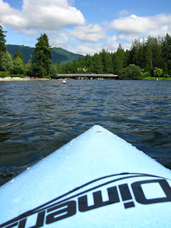
Found some blue sky out at Lake Samish this afternoon and was able to take advantage of it with the kayak.
Being a total newbie to the world of kayaking, Lake Samish was a perfect spot for the day. A loop of the western cove (between the bridge, Whatcom County's Lake Samish Park and Lutherwood) provided a nice mix of scenery with spurts of windy gusts and waves from powerboats and jet skis.
Took a couple of photos, but seriously, is that kid smoking? Unbelievable.
Found a number of rope swings on the north side of the cove, not sure if they are private property or if they were just placed on timberland and yet to be discovered/removed.
The kayak remains waterproof. The spray skirt and waterproof bags have been very handy too.
Not having much experience in any other types of kayaks, it's hard to know just how well (or not well) this kayak performs. Hopefully a trip to 'the island' in July will give me a chance to compare my vessel with my dad's Pungo (which is about 3 feet longer).
While researching local places to kayak I stumbled upon a website called Paddle Heaven. It's seems to have a plethora of useful kayak related information.
Anyone interested in local kayaking, I highly recomment that you visit the Paddle Heaven website AND get in touch with me... I'm seeking kayak buddies -- inexperienced or experienced... either (or both) would be greatly appreciated.
Have no fear, fellow hikers, the boots remain ready for some awesome summer adventures on the trail. Praying for conditions suitable to enjoy views from Cascade Pass (or higher) in two weeks!
Happy Hiking (or Paddling)!
~E
PS: Still owe you a trip report for Sourdough Mtn and Goat Lake. Hopefully both will be posted this week sometime.
Subscribe to:
Posts (Atom)