Sunday, December 13, 2015

Wallace Falls 12-12-2015

Four Mount Baker Club members ventured out to Wallace Falls State Park located off Hwy 2 in Snohomish County to check out this incredibly scenic trail.  The tall cedar trees, lush moss and high volume of water rushing down Wallace River did not disappoint!  The route was easy to follow and offered a wide variety of viewpoints along the way. 

We paused for photos at the Lower, Middle and Upper Falls.  Additional photos were taken at the Valley Overlook and along the interpretive trail.

As we emerged from the forest canopy on our return we encountered significantly more rain and substantial wind.  Neither were abundant under the protection of the Cedars.

Round trip was about 6 miles and about 1,800 feet of cumulative elevation gain (I think the gps profile image is overstating the cumulative elevation gain/loss).

The Wallace Falls State Park is located just outside the little town of Gold Bar.  A Discover Pass is required for parking at the State Park.  Dogs are allowed but must remain leashed at all times.


Check out the list of upcoming hikes hosted by the Mount Baker Club by visiting the Mount Baker Club Activities Page.

Saturday, November 22, 2014

Skokomish High Steel Bridge 10-17-2014

Day 2, Part 2

After a failed visit to the Elwha River dam site, we set out to locate the 'High Steel Bridge'.

Honestly, it's not clear how, why or when the 'High Steel Bridge' came to my attention, but it immediately captured my interest.

Whatever or wherever I first saw pictures of it we may never know.  My first impressions were that this was a railroad bridge which was somewhere in the middle of nowhere.  It appeared potentially run down... maybe totally forgotten about.  Possibly just a leftover of prior times, now unclaimed and almost forgotten.  The 'mystery' of this location, this relic, had the same kind of feeling that I had when I first found Dirty Harry's Museum back in 2007.

Then, in a complete coincidence, while we were discussing the itinerary for this weekend outing (less than 12 hours prior to my departure from home) my Dad mentioned something about a really high steel bridge that maybe we should try to find.  ***Connection!***

We quickly agreed that we were thinking about the same structure and added it to our to-do list.  Luckily, he knew a little more about it than just 'high steel bridge'.  With the help of Google Maps we were able to locate the structure and backtrack the roads to civilization.

Since the weather had turned 'significantly wet' we were pretty glad to learn the road would take us all the way to the bridge.  It wasn't clear what we would find when we arrived... would we have to park and hike an abandoned railroad route to get there?  Would we be able to drive right to it and drive over it?  We didn't know.

Long story short... yes, the road goes directly to the bridge and yes you can drive over it.  You can drive beyond it but honestly I have no idea where the road goes.

We parked the truck and walked across the bridge and then walked back.  Then we drove over the bridge and then drove over it again.  We survived.

The views are pretty impressive but the moody weather wasn't very helpful in getting photos - it was raining buckets.

Here are the photos I could salvage.  They are a bit blurry... let's just say that adds character to them.


I accidently deleted the gps route to get here, but admittedly, half the fun was figuring out which route to take to get here.  So, instead of trying to piece that info together for you... you'll get a kick out of trying to find it yourself.  :)

Stay tuned for the final destination of this awesome weekend:  Fudge Point

Happy Hiking!

~E

Saturday, November 15, 2014

Spruce Railroad Trail 10-17-2014

Day 2, Part 1

After 'car camping' at a no-frills motel in Port Angeles to avoid being rained on we awoke to cloudy skies but no rain.  Of course, this is Port Angeles so the Rain Shadow plays a big role in the precipitation.  Had we stayed in a tent near Lake Crescent it would have been a wet night.

From the motel we went directly toward the eastern end of the Spruce Railroad trail.

At the last junction before reaching the trailhead we noted a notice posted to a sign.  The notice informed us that the trail we had been planning to hike was officially closed until further notice because of trail work being done.

Well... we decided to take our chances at this trail head instead of making the 30 minute drive to the western trail head.  Glad we did!

At the trail head we encountered a caterpillar/bulldozer and a Forest Service truck.  Considering it was a week day there was a high liklihood that construction would be in progress and we would be asked to hike the other end of the trail.  Fortunately, that wasn't the case.

The Forest Service employee we talked to indicated the construction had just finished up and although the trail may not be officially posted as open, there wasn't any reason why we wouldn't be able to do the hike as planned.  This was great news because the highlights of the trail are much closer to the eastern trail head than the western trail head.

The trail highlights that we were seeking included "The Devil's Punchbowl" and at least one Train Tunnel.

We were able to visit the Punchbowl and both entrances to the first tunnel.  In addition, we were able to enjoy the newly constructed trail (wheelchair accessible, probably) and a couple nice new steel/concrete bridges.

Photos below, followed with more trail detail information.


The trail has a couple minor hills, but is mostly flat.  My GPS indicated that we only changed elevation by 58 feet over 5.5 miles of trail (round trip).  That sounds pretty flat... I believe we had a bit more elevation gain than that, but probably less than 200 feet, cumulative.

The first quarter or half mile of the trail is very wide and well constructed... probably wheelchair accessible.  The bad news is that this section of trail doesn't go down to the lake, nor does it have any views of the lake.  It's only reward is the forest views and a bridge or two with a typical creek running underneath it.

At the end of this freshly constructed trail, it veers rather steeply downhill to the left, toward the lake.  This section is definitely not wheelchair friendly.  Steep, dirt, tree roots and narrow.

The trail then levels out near the lake.

We then came to an unexpected junction.  Up to the right or down to the left.  We chose down to the left.  We took the uphill to the right trail on our way back to the car... it leads to the eastern opening to the tunnel.  You should check it out... doesn't matter if you do it on the way in or on the way out.  Just do it.

Heading down to the left we finally reached the Lake... and Devil's Punchbowl, with a cool bridge crossing the 'bowl' at lake level.

A short distance later there is another trail heading uphill to the right... this will bring you to the western entrance to the tunnel.  Go check it out too.  Both tunnel entrances are accessible, but both are also intentionally sealed with huge, sturdy walls.  We didn't get close enough to touch them, but they appeared solid and sturdy... no way to peek behind them or to get further inside.

Back on the main trail, we continued on for a ways.  There were some nice lake views and nice views of the surrounding hills, but nothing too noteworthy and we turned around at about 2.5 miles. We discussed the option of one of us continuing onward to the western trail head and the other person would drive around to pick up the hiker.  Ultimately we opted to stick together... a good choice.

The rain started when we had about 1.25 miles of hiking to go.  It rained moderately hard... and that was ok since we had expected to be rained on most of the hike.  We really lucked out!

In my opinion, we probably didn't miss anything super cool by not hiking all the way to the western trail head.  However, somewhere along that section there is reportedly a trail junction that will take you to the top of Pyramid Mountain.  That may be a better choice for hikers looking for something with more elevation, obviously.

All in all, the Spruce Railroad hike, beginning at the east Trailhead is definitely worth visiting!

Our next destination was supposed to be the Elwha River (former) Dam site.  Unfortunately, when we drove out there we were disappointed to find out the entire area is closed due to continued 'removal' 'construction'.  No access, no view, no nothing!  --face palm--

Back to Port Angeles for lunch at Subway before returning to Port Townsend to pick up the second vehicle and then onward to find the Skokomish High Steel Bridge!  Report coming soon...

Happy Hiking!

~E

Thursday, November 13, 2014

Salt Creek Recreation Area 10-16-2014

The final exploration for Day 1 of our Cape Flattery trip consisted of a brief visit to the Salt Creek Recreation Area off Hwy 12, west of Port Angeles in northwest Washington.

My previous and only visit here was with a friend back in June 2007 as part of a trip to Sol Duc Hot Springs.  That visit is mentioned briefly in my trip report on nwhikers.net.

During that original trip we made a nice tour of the beach area, including the Tongue Point Marine Sanctuary... highly recommended if you visit this area... particularly at lower tides so you can also enjoy the tide pools.

This trip we were more interested in the remnants of Camp Hayden since we didn't take the time to check it out in 2007.

According to a Clallam County Parks website, Camp Hayden was used as a harbor defense military base during World War II.  "The remnants of World War II Camp Hayden are preserved on the site - two concrete bunkers which housed 16" cannons and several smaller bunkers."  

These remnants are easy to access, but they aren't visible from most places in the park.  You'll find them at the top of the hill, above the campground areas.  Follow the paved road to the left... or find one of the trails from the campground/beach area and head uphill... staying west of the Striped Peak Recreation Area.

You can drive the road directly to, and under, the bunkers.  You'll find a parking area and informational signs.  Park the car, get out, explore.

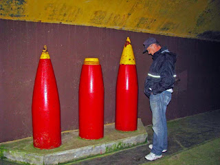
We did just that.  Walked around and under the bunkers.  Walked into pitch black rooms.  Took flash photos with cell phones and cameras.  Jumped up to snap pictures in windows that were too high for us to look in.  Tried to open monstrous doors blocking access to unimaginable mysteries beyond. Checked out huge missile casings.  All good stuff.  Looked a lot like this:


While the sights were impressive, I was hoping to be surprised by locating other bunkers nearby.  Maybe we would find some off a trail or somewhere other than the 'in your face' 'you can't miss it' bunkers on the top of the hill.  Unfortunately, there weren't any others that we found (except the one right on the beach as you head to Tongue Point, but that doesn't count either).

Visit to Fort Ebey and Fort Casey on Whidbey Island both had some 'unexpected surprises'.  Turn a corner and "Hey!  Look!  A bunker we didn't expect!"  As noted... we didn't find any such surprises at Salt Creek.

Regardless, it's still a cool place to go visit and explore.  Bring the kids... they'll LOVE it!

Link:  Salt Creek Recreation Area Map.

Once we finished our exploration of the Salt Creek Recreation Area, we considered venturing out on a hike up Striped Peak (since the western trail head is located in the Salt Creek Rec area) but we opted to find a short cut back to Lake Crescent and then figure out our lodging and dinner plan instead.

This concludes (most) of Day 1 adventures.

Day 2 objectives include the Spruce Railroad Trail, the Elwha River (former) Dam site and to track down the Skokomish High Steel Bridge.  Those stories will be coming soon.

Happy Hiking!

~E