Monday, July 25, 2011

Lily and Lizard Lakes - Chuckanuts 07/16/2011

Lily and Lizard Lakes up in the Chuckanut area is a very popular hike for Whatcom and Skagit County folks year round.

It's low elevation makes it easily accessible and typically snow-free.

Due to the unfavorable weather forecast for July 16, 2011, this became my destination for the day.


The day was drippy, with bouts of fog and no views.

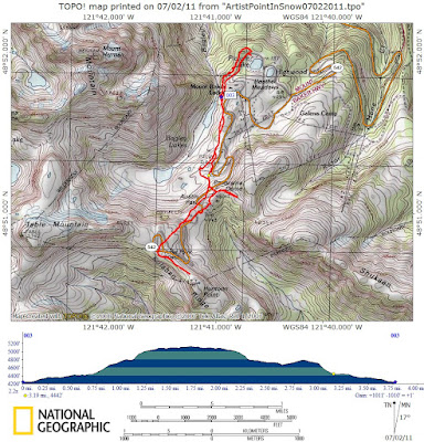
There are a number of routes that lead you up to the lakes. For this particular hike, I parked at the Lower Trailhead (accessible via Barrell Springs Road) and took the 1 mile trail to the Upper Trailhead and then the traditional trail the rest of the way to the lakes. GPS based route image is down near the bottom of this report.

An alternate route is via the Incline Trail, which may actually have been shorter - but the first part of it follows a gated road. A short exploration up the road led me to a clearing that 'could' offer some views in better weather.

My round trip route was 10 miles and about 2,000 feet of net elevation gain. YOu can shorten the trip by 2 miles if you park at the upper trail head. I recommend the upper trail head because you aren't missing anything if you don't hike the 1 mile trail between the two starting points. The only benefits to the lower trail head is that it sports an outhouse, gives you a chance to hike a little bit further, gain a little extra elevation and MAYBE you'll find a porcupine on the trail.


Another route option is to combined the trip with a hike to Oyster Dome, then take "Max's Shortcut" from the Oyster Dome trail to go directly to the lakes.

The regular trail parallels the road that heads toward Samish Overlook for about a mile before making a switchback and begins to gain elevation.

At the first trail junction, continue straight ahead. The junction isn't signed, but I suspect the trail to the left connects back to the Samish Overlook parking lot.

The trail simply ascends through the forest on good tread. There are periodic boggy areas and once in a while you'll come across some resting benches.

Finally, you'll reach a second intersection that has very clear signs. Lily Lake to the left, Lizard Lake (and the Incline Trail) to the right.


I choose to go the the right (Lizard Lk) first.


Then I back-tracked to Lily Lake.


Reportedly, from Lily Lake you can head up hill (off trail) to scout out the local high point, which is marked with a survey marker. I considered this option, but the poor weather and longer-than-expected mileage left me unmotivated to tackle that destination. Will do it on a better-weather day.


All in all, it was a great hike for the conditions. If you want to introduce someone to a typical 'great northwet forest', come here on a cloudy or drippy day.


Brought along a special snack for the hike today:


Despite being a summer weekend, I only encountered two other people on the trail during my four hour visit.

****The new Discover Pass is required at the Lower TH, the Upper TH and also at Samish Overlook. You cannot buy one at either the Upper or Lower lot as of my visit. Consider driving back down to Chuckanut and parking at the Oyster Dome/Bat Caves trail head where I think passes are not required. This will add miles and elevation to the Lily/Lizard Lake destination, so plan accordingly.****


Happy Trails!

~E

Saturday, July 23, 2011

Middle Fork Nooksack River Diversion Dam 07/10/2011

While on the way home from my first visit to the Goat Mountain trail off the Mount Baker Highway, I followed advice from Aaron to go visit the Diversion Dam on the Middle Fork of the Nooksack River.


This was my first visit to the Middle Fork Nooksack River Road. It's in great condition fr the first few miles - which is all I needed to drive before I located the spur road to the diversion dam.


The diversion dam was reportedly built to divert water from the Nooksack River and into Lake Whatcom... for the purpose of ensuring Lake Whatcom will be around for a long time as it is a staple water source for Bellinghamsters.


The spur road descends about 400 feet to the dam over the course of .75 mile or so. The road is heavily eroded from water, making it impossible for vehicle travel (except the uber-4x4's, ORV's or maybe a tank). It doesn't matter though, because the road is blocked with a gate.


I was surprised to find the bridge over the river and I was surprised at the size and complexity of this diversion dam. Much more to it that I would have anticipated and I really wish I had someone with me who could provide more info about the design. Why is it so complex? So intriguing. Such a mystery.


The river channels into a pretty deep gorge after it passes by the dam. It's hard to tell from the bridge whether the gorge is natural or whether it was created/modified as part of the dam construction.


I think I pinpointed where the diverted water goes into the tunnel, but it's just a guess... and I have no idea how large of a diameter the tunnel is. Six feet? 20 feet? 50 feet? No idea.


Also, where is the other end of this tunnel? There must be an access point at the other end, right? Somebody had to build something down there... where is it? Better add that adventure to my "Rainy Day Dumpster Dive To Do List".


This was a neat little adventure to an area that is new to me and I'm looking forward to more adventures and explorations further out the Middle Fork road in the future.


Here's a video with most of the above pictures, but also some real video footage I recorded while at the dam.


Happy Trails!

~E

Saturday, July 16, 2011

Goat Mountain (kinda) 07/10/2011

After driving by the Goat Mountain trail head a couple weeks ago with Jen & Janet it's been on my mind. J & J mentioned the great views from the higher elevations, but weather and views weren't likely during the Summer Solstice outing (due to weather).

So, with a pretty decent weather window and a schedule opening one Sunday morning I found myself at the Goat Mtn Trail Head.


This particular Goat Mountain is the one accessible via the Hannegan Pass road, off the Mount Baker Highway (Hwy 542) in Whatcom County.


Due to the mild climate this year, it was inevitable that I'd reach the snow level on this hike and knew that meant I'd be back another day to finish the hike.

When I say "Mild Climate" I mean "Really Crappy Weather for a long time".


The question was simply a matter of "How high can I go before I lose the trail in snow... and will there be any views?"


Most of the lower trail is in a beautiful forest, with many small creek/stream crossings. These are all fed by the snowpack melting from higher up - I suspect that in most years the streams disappear by the end of summer, making this a dry trail at times.

The hike itself, solo, wasn't too exciting.


Crossed paths with two other people. One was just finishing the trail as I started and the other was a nice lady with her two dogs. The first person claimed to have made it to the former lookout site, about a quarter mile after the snow starts. The second person turned around at snow line.


According to my guide book, there is a side trail that leads to the former lookout site... with nice views available. My hope was that I'd find the junction (snow free) and enjoy the views.


Well, I found a 'faint' side trail just after crossing into the Mt. Baker Wilderness, but it was too faint for me to follow solo - although I did follow it for a ways. After ducking under three trees and crossing three streams and the path was becoming more and more overgrown... I started to doubt whether or not this was the right side trail. There was no snow here, so it contradicted what the other hiker had told me. So, I turned back and will save it for another time.


I continued onward and finally reached the snow line. I continued onward for a short ways, just long enough to get up to snap these two shots and then decided to call it a day.


The trail is a bit steep (it's typicaly Cascade Steep) but it was a really nice trail and provided beautiful forest scenry. Also, the trail was very clean... not a speck of garbabe to be seen.


Happy Trails!

~E

Itinerary for 07-16-11

It's a pre-scheduled hike day but the weather looks pretty wet everywhere west of the Cascade Crest.

May as well save the gas money and just hit somewhere close to home, without views... such as Lily & Lizard Lake in the Chuckanuts.

While exploring that area I'll probably try to use my enhanded GPS skills to find the high point of the area (just southwestish of Lily Lake... or Lizard Lake). Guess I'd better bring a map.

If all goes well (fast and not feeling like a sponge), then I'll probably drive over to Cranberry Lake in Anacortes to see what I'm missing out there.

Happy Trails!

~E

Tuesday, July 12, 2011

Artist Point Eye Candy 07-02-2011

Yet another trip to Heather Meadows / Artist Point?

Yep!

The sun was out (as was the sunscreen) and it was a great day for a summer snow trip... with views! Shorts, T-shirt & a hat. It's about time!

No snow shoes were needed since the snow is very consolidated. It also gets slushy as it warms, so traction isn't always a sure thing. That's ok... because it makes for great glissading opportunities. Plus, those Sun Cups means it's hard to gauge exactly when/how your foot is going to touch down.


My route consisted of heading up to Artist Point (via Cardiac Hill as some people call it) for lunch. As you can see, the road runs under some cornices the could be a potential risk.


On the way back down I pinpointed the Lk Ann trail head (always curious about where it is in winter), headed part way up Panorama dome just to enjoy a 200 foot vertical glissade on the way down.


Here is a shot of the snow level at the Lake Ann Trail Head:


During my last visit here back in mid-June, only the black pipes of this restroom were visible.


Once back to the parking lot, opted to head off in the opposite direction along another rumored snowshoe route. Rumored because I've heard about it, but never actually heard of anyone doing it.

Now that some of the snow is melted ('some' is the key word here) it appears there could be a legitimate summer trail underneath the rumored snowshoe route. Will have to investigate that this summer (or next summer if the snowpack hangs in there).


Followed the trail for a good distance with the GPS and came across a Grouse which actually hung around long enough for a picture and a video!

Shortly thereafter I arrived at the Mountaineers Lodge (nice looking place)!


Feeling tired and sensing that there wasn't going to be a lot of new scenery, decided to make my way down to Picture Lake, snap a few photos and then return to the car via the road and a little cross-country travelling.


Here is a picture of "Baker" Honey Buckets at the base of Mt. Shuksan (click to enlarge). hahaha.


Here is the Galena Creek Falls, which most people miss even though they drive right next to it on Hwy 542.


Route Image:


Happy Trails!

~E