Merry Christmas everyone!
We'll be trying to fly out to Phoenix on Christmas Eve... so I'm just posting some early holiday greetings.
With our flight cancellations there is a slight chance my book might be delivered before we leave the house ... it would be a Christmas Miracle! I could share it with stranded Seatac passengers and other captive audiences throughout our trip.
:)
Hopefully it meets my expectations.
The Jan. 10th outing is still a tentative date but it will be nice to play in the snow in the Mountains instead of the lowlands. Sheesh... enough already! Bring on the rain!
Merry Christmas!
Tuesday, December 23, 2008
Wednesday, December 17, 2008
Hey Look! It's a book!
Many people have switched from film cameras to digital cameras. Logically, a lot of people order prints online. Many websites that provide the prints also offer other opportunities to 'make stuff' with your photo... like a photobook. Like a scrapbook, but easier for those of us who aren't so hands-on-artsy-fartsy.
I contemplated making a photobook for quite a while... and then threw one together at www.lulu.com which contains only photos from hikes during 2008. In the end, it was way too expensive for pages of pictures and nothing else. It was all pictures. No words, except a title. I was disappointed. Plus, it felt like I was picking at the bottom of the barrel for a few of the pictures.
Then I found www.blurb.com.
So, I started pulling together somthing that was much more than a photobook. Well, it feels like 'more than a photobook' to me because it actually has some text in it and I was able to put in most of my favorite photos while ignoring the crappy photos. Additionally, I think it flows pretty well from start to finish without getting too wordy or dull.
I ordered one for myself just the other day and can't wait to see the finished product. Unfortunatly, due to the busy shipping season (and a family vacation), it probably won't arrive until the end of the month.
You can preview the first 15 pages online by following the link to blurb.com:
Big Rock Excursions 2004-2008
Really, the first 15 pages just don't do it justice in my opinion, but I'll gladly show you my copy next time we see each other.
The full book is 72 pages long, with more than 100 pictures and 40 different destinations taken over a 4 year period and encompassing 70 "hike days" overall. Many of you who have hiked with me have your picture in the book as well, including: Dad, Rob, Erik, Steve, Chris, Tim, Kyle, Rachel and of course my family.
My original photobook (with a full online preview) posted at lulu.com can be viewed here: 2008 Photobook
It's a little cheaper than the blurb version, but I really think the blurb version is 100x better. In fact, I'm not even ordering the lulu version for myself.
With all that out of the way, you can look forward to the 2008 Video that I'll be creating over the next few weeks.
Next outing is tentatively scheduled for January 10, 2009. Now that we have some snow, I'll be looking forward to some good snowshoeing and might start off with a trip to the popular Skyline Lake at Steven's Pass. As always, the date and destination are subject to change at anytime.
Cheers to you all and have a Merry Christmas!
Sunday, December 7, 2008
Snow Lake 12/06/08
Well... I was right. There was less than a foot of snow on our hike. In fact, there was absolutely NO snow at Snoqualmie Pass. Good thing I left the snowshoes, avalanche transceiver, shovel and probe at home as they would have just been extra weight.

Click here for the official Snow Lake Trail description.
This trail is very popular in the summer, frequently having 800 visitors on the weekends. In the winter, however, the avalanche prone slopes keep most people away from this area. Without snow, we shared the trail with a few people, but they were few and far between.
The weather was fantastic!
I left home about 6:40am and enjoyed watching the colors of dawn grow over the cascades as I cruised south toward Lynnwood to pick up Steve at 7:30am.
Dawn and Mt. Pilchuck (from the car):

Dawn and Mount Rainier (from the car):

Here are a few of the views you may get to enjoy from this trail on a sunny day:
Tree and reflection in distant lake:

Early view of Snow Lake, from the ridge

The trail was snow-free, but did have sections of solid ice, due to snow melt and recent rains and runoff combined with cold weather. Once over the ridge to descend toward the lake the amount of ice increases drastically. We put on extra traction devices for safety and they worked great! I like Stabilicers and Steve likes Yak Trax.
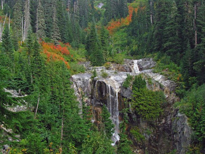
Waterfall and Ice

Structure Remains (not sure what this was - possibly a ranger station or private cabin?)

View across Snow Lake

Frozen Waterfall

Frozen Tarn, with sun

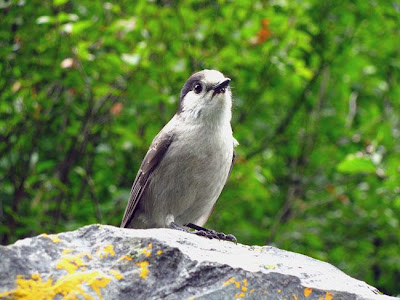
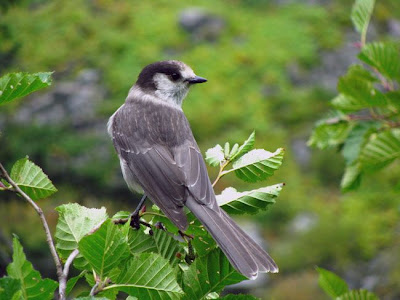
Grey Jay on my Hiking Pole:

Southern View of Alpental and valley

Pika above Source Lake

Another view of Snow Lake

Tibetan Prayer Flags:

Cousin of Loch Ness Monster? No, just a floating log I guess.

Glinda, the good witch, tries to interrupt a photo opportunity.

Here is a short video (90 seconds) of some clips I shot during this trip... just experimenting with various settings.
Thanks for reading my trip report. A similar version is available here at nwhikers.net.
Next outing is scheduled for Saturday, January 10th, 2009... more than a month away.
Click here for the official Snow Lake Trail description.
This trail is very popular in the summer, frequently having 800 visitors on the weekends. In the winter, however, the avalanche prone slopes keep most people away from this area. Without snow, we shared the trail with a few people, but they were few and far between.
The weather was fantastic!
I left home about 6:40am and enjoyed watching the colors of dawn grow over the cascades as I cruised south toward Lynnwood to pick up Steve at 7:30am.
Dawn and Mt. Pilchuck (from the car):
Dawn and Mount Rainier (from the car):
Here are a few of the views you may get to enjoy from this trail on a sunny day:
Tree and reflection in distant lake:
Early view of Snow Lake, from the ridge
The trail was snow-free, but did have sections of solid ice, due to snow melt and recent rains and runoff combined with cold weather. Once over the ridge to descend toward the lake the amount of ice increases drastically. We put on extra traction devices for safety and they worked great! I like Stabilicers and Steve likes Yak Trax.
Waterfall and Ice
Structure Remains (not sure what this was - possibly a ranger station or private cabin?)
View across Snow Lake
Frozen Waterfall
Frozen Tarn, with sun
Grey Jay on my Hiking Pole:
Southern View of Alpental and valley
Pika above Source Lake
Another view of Snow Lake
Tibetan Prayer Flags:
Cousin of Loch Ness Monster? No, just a floating log I guess.
Glinda, the good witch, tries to interrupt a photo opportunity.
Here is a short video (90 seconds) of some clips I shot during this trip... just experimenting with various settings.
Thanks for reading my trip report. A similar version is available here at nwhikers.net.
Next outing is scheduled for Saturday, January 10th, 2009... more than a month away.
Friday, December 5, 2008
Itinerary for 12/06/08 Dayhike to Snow Lake
Meeting Steve in Lynnwood at the Park & Ride just north of I-405 at 7:30am and heading off toward Snoqualmie Pass with the expectation that we'll hike to Snow Lake.
Near as I can tell, there is less than a foot of snow up there, but we'll have snowshoes along, just in case we need them. By this time of year this trail is typically buried deep under snow and used as a snowshoe route, in the right conditions. Obviously we're a little light on the snow so far this year.
We should have plenty of time for the approx. 6 mile round trip trail before dark.
Steve has been on this trail before (although it was some time ago) but this is 'new to me'. Also, my eTrex GPS is officially a paperweight now, so it will be staying home, leaving us to a map and compass in the event we decide we're lost.

The backup plan is to tackle Granite Mountain... which is on my hit list after being denied the summit last month.
Pics and report to follow soon...
Happy Trails!
~E
Near as I can tell, there is less than a foot of snow up there, but we'll have snowshoes along, just in case we need them. By this time of year this trail is typically buried deep under snow and used as a snowshoe route, in the right conditions. Obviously we're a little light on the snow so far this year.
We should have plenty of time for the approx. 6 mile round trip trail before dark.
Steve has been on this trail before (although it was some time ago) but this is 'new to me'. Also, my eTrex GPS is officially a paperweight now, so it will be staying home, leaving us to a map and compass in the event we decide we're lost.
The backup plan is to tackle Granite Mountain... which is on my hit list after being denied the summit last month.
Pics and report to follow soon...
Happy Trails!
~E
Sunday, November 30, 2008
Next outing is 12/6/08 (Saturday)
My apologies for the late notice, but family events are going to prevent me from hitting the trails on Dec 13th as originally planned.
The only other open date I have is this coming Saturday: December 6th.
I'll check into weather and snow conditions in the next couple of days and come up with a tentative itinerary.
Off hand, maybe I'll head to Artist Point if the ski area hasn't opened... or maybe I'll head out to Lake 22 off the Mountain Loop Highway or possibly try to squeeze in a longer day at the Iron Goat trail out near Steven's Pass.
Drop me a note and let me know if you are available and interested for Dec 6th.
Thanks!
Saturday, November 15, 2008
Granite Mountain Trip Report 11-15-08
Granite Mountain has been on my to-do list for a few years and almost all the pieces fell into place today to make this a reality.
This trail is located just off I-90 at Exit 47. For those of you who aren't familiar with the area, it's about 47 miles east of Seattle, just before Snoqualmie Pass (where I-90 crosses from Western Washington into Eastern Washington).
Due to it's ease of access and proximity, the trail is used frequently - despite the 3,839 feet of elevation gain over 4.3 miles. So, it's steep - but not excessively steep, by Cascade standards anyway. The trail ends at about 5639 feet above sea level.
This hike has a couple of unique features:
The main attraction is the Fire Lookout that is located at the top of Granite Mountain. You can actually see the lookout from I-90, but today is the first time I've ever noticed it.
The second main attraction is the alternative 'scramble' route that follows the final ridge. You can either follow the regular trail (longer) or you can take the shorter 'scramble' route over and around boulders along the final ridge toward the Lookout.
The third main attraction, when the weather cooperates, are the fantastic views... including Mount Rainier. As a side note, due to all the recent flooding, almost all of the Mt. Rainier National Park is closed until this next Friday.
Lots of nice people on the trail today, but no wildlife of any kind --- except for bugs (believe it or not).
Pictures (in no particular order):


Despite the fantastic weather and great views, my body simply wasn't willing to cooperate on the trail today. Calf and thigh cramps started to plague me at about the 2 mile mark and despite my slowing pace, frequent hydrating and eating they wouldn't relent.
When my turnaround-time alarm sounded I was so close to the lookout, but my pace was only slowing and the cramps were increasing... so I'll have to head back next summer to finish the last 300 feet of vertical.
Even so, it was a beautiful day on the trail and I'm glad I became familiar with a trail that is 'new-to-me'.
Next outing is scheduled for December 13, 2008 but that date may have to change to accommodate family Christmas plans. Pleas stay tuned... or contact me to discuss it.
~E
This trail is located just off I-90 at Exit 47. For those of you who aren't familiar with the area, it's about 47 miles east of Seattle, just before Snoqualmie Pass (where I-90 crosses from Western Washington into Eastern Washington).
Due to it's ease of access and proximity, the trail is used frequently - despite the 3,839 feet of elevation gain over 4.3 miles. So, it's steep - but not excessively steep, by Cascade standards anyway. The trail ends at about 5639 feet above sea level.
This hike has a couple of unique features:
The main attraction is the Fire Lookout that is located at the top of Granite Mountain. You can actually see the lookout from I-90, but today is the first time I've ever noticed it.
The second main attraction is the alternative 'scramble' route that follows the final ridge. You can either follow the regular trail (longer) or you can take the shorter 'scramble' route over and around boulders along the final ridge toward the Lookout.
The third main attraction, when the weather cooperates, are the fantastic views... including Mount Rainier. As a side note, due to all the recent flooding, almost all of the Mt. Rainier National Park is closed until this next Friday.
Lots of nice people on the trail today, but no wildlife of any kind --- except for bugs (believe it or not).
Pictures (in no particular order):
Despite the fantastic weather and great views, my body simply wasn't willing to cooperate on the trail today. Calf and thigh cramps started to plague me at about the 2 mile mark and despite my slowing pace, frequent hydrating and eating they wouldn't relent.
When my turnaround-time alarm sounded I was so close to the lookout, but my pace was only slowing and the cramps were increasing... so I'll have to head back next summer to finish the last 300 feet of vertical.
Even so, it was a beautiful day on the trail and I'm glad I became familiar with a trail that is 'new-to-me'.
Next outing is scheduled for December 13, 2008 but that date may have to change to accommodate family Christmas plans. Pleas stay tuned... or contact me to discuss it.
~E
Friday, November 14, 2008
Itinerary update for 11/15/08
Opting to head southward to take advantage of a more favorable weather forecast.
I expect to spend my day on Granite Mountain, located at about Exit 47 off I-90. Here is a recent trip report from the Lykkens.
Depending on how much snow there is and the amount of light remaining when I return to the car, I may stop to check out Twin Falls State Park or a section of the John Wayne Trail crossing Change Creek as well.
Unfortunately, all my BFF's are otherwise engaged today (or maybe they are just smart and waiting for a better weather opportunity) so I'll be hiking solo.
It seems that my GPS unit finally gave up the ghost during my last outing, so, Santa, if you're reading this you should read up on the Garmin 60CSx. In the meantime, I'll continue to carry a map & compass (and hopefully not have to use them).
Happy Trails!
Thursday, November 6, 2008
2009 Hiking Calendar
**Disclaimer: This will probably change, but for now it is what it is. Schedule at your own risk.**
Changed to Jan 17th (3rd Saturday of the month). Went to Skyline Lake for a beautiful sunny day of snowshoeing.
Changed to Feb 8th (2nd Sunday) - Postponed to Feb 21 -- Cancelled to take Alexia skiing (despite doctors reluctance).
Mar 7th (1st Saturday) - just after my birthday but well before Spring Break. -- Cancelled due to conflicting family schedules & medical tests. Did manage to get a short outing in at Point Defiance (sure, that counts!) on the 29th.
Apr 8th - took a day off work to play around at Heather Meadows and Cedar Lake.
Apr 18th (3rd Saturday) - RESCHEDULED for APRIL 26TH.
May 16th (3rd Saturday) - the weekend after Mother's Day (too late to use the 'shopping' excuse) - RESCHEDULED to May 23, 2009 (Saturday)
June 13th (2nd Saturday) - the weekend before Father's day weekend. Certainly your family will get enough of you on that day so you can escape for a day of hiking. Or... it's your early Father's Day present. Everybody wins!
July 11th (2nd Saturday) - weekend after the 4th of July.
Aug 8th (2nd Saturday)
Sept 13th changed to Sept 5th (1st weekend) - pressured by State Fair and Ushering duties at church, this hike will have to be during the Labor Day Weekend.
Oct 5th? (first Sunday) - Since I'm not getting an end-of-September hike and the hike scheduled for next weekend has turned into something 'bigger', I'm going to try to hit the trail this Sunday with hope of good fall colors. It could just as likely occur two weeks later I suppose. Based on how busy we've been... this is unlikely to happen, but I do have some time off to used before the end of the year, so I'm keeping my eyes open for a weekday outing possibilities during Oct/November before the deep snow arrives.
Oct 10/11 (Saturday/Sunday) - Special trip... invite only.
Nov 14th (2nd Saturday) - before Thanksgiving of course.
Dec 12th (2nd Saturday) - before everyone departs on Christmas vacations.
Feel free to watch my video that summarizes my 2007 hikes:
If you made it through that video, feel free to watch this slideshow of photos taken from our house over the last nine months:
xx This link temporailly broken xx
Thanks for reading and watching!
Saturday, November 1, 2008
Next Outing is 11/15/08 (Saturday)
Not sure what the conditions will be, nor the destination... nor the participants. The only thing I do know is that I will be enjoying outdoor recreation somewhere.
Hopefully with someone(s).
Some repeat destinations that I'm eyeing (if the snow holds off) include Park Butte Lookout (Mt. Baker), Kendall Katwalk (I-90 @ Snoqualmie) or the Iron Goat Trail (Hwy 2 @ Steven's Pass).
Check your calendar and let me know.
Participant Update:
Rob: Green light
Hopefully with someone(s).
Some repeat destinations that I'm eyeing (if the snow holds off) include Park Butte Lookout (Mt. Baker), Kendall Katwalk (I-90 @ Snoqualmie) or the Iron Goat Trail (Hwy 2 @ Steven's Pass).
Check your calendar and let me know.
Participant Update:
Rob: Green light
Sunday, October 12, 2008
Railroad Grade (Mt. Baker) 10-12-08
Managed to convince my sister and brother-in-law to drive up from Pierce county this morning for a beautiful day on the south side of Mt. Baker.
They brought their energetic 9-month-old puppy along for his first real hike also.
Due to his age they were worried about the distance so we limited the trip to visiting the Railroad Grade instead of the Park Butte Lookout.
Round Trip for our route was almost exactly 6 miles and just shy of 1,800 feet of elevation gain.
The 'Railroad Grade' trail is a great trail because of its varied terrain and fantastic mountain views. Here is a short video of what hikers see as they first gain the 'Railroad Grade':
We also crossed paths with Slugman and Daisy the Wonder Dog. It was great to meet you Slugman and we hope you had a comfortable night on the mountain.
Fresh dusting of early season snow on the Black Buttes:
Twisted & Downed Tree: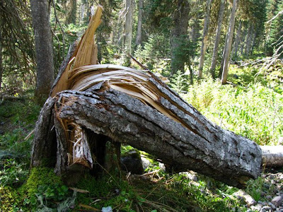
View of Survey Point from the switchbacks along the trail: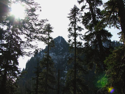
Remains of snow from earlier this week:
Rudy & his Rude Roo Bag, pretending his 'stuff' doesn't stink: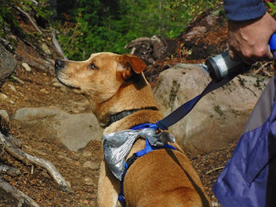
Crater & Steam on Mt. Baker: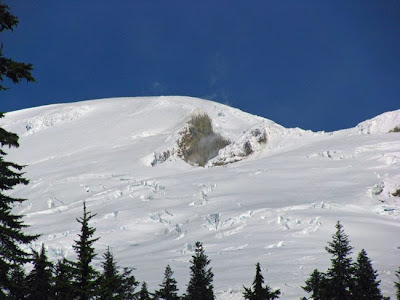
Approaching Railroad Grade, with Black Buttes in the distance:
Zoomed View of Park Butte Lookout from the Railroad Grade Trail (we were about 1 mile as the crow flies from the lookout when we reached the Railroad Grade):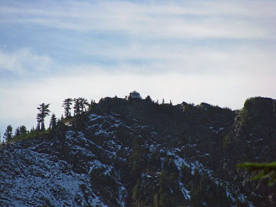
The Black Buttes are the internal remains of a volcano that was larger than Mt. Baker (so I hear):
View of Cathedral Crag from the RR Grade Trail: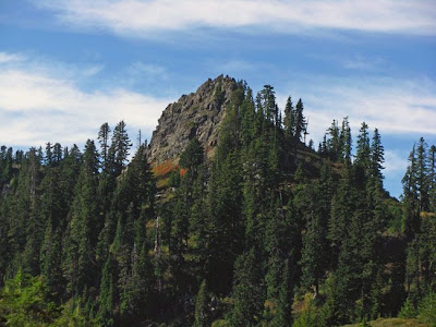
Railroad Grade Trail follows a Lateral Morraine up to the Easton Glacier on Mt. Baker: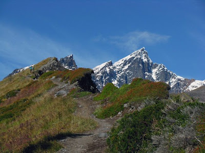
Looking back toward the Park Butte Lookout (atop the ridge, about 1 mile as the crow flies):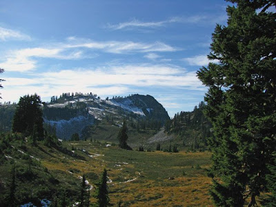
Rudy watching a Robber Jay eat his lunch: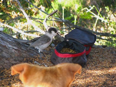
Back into Upper Schriebers Meadow: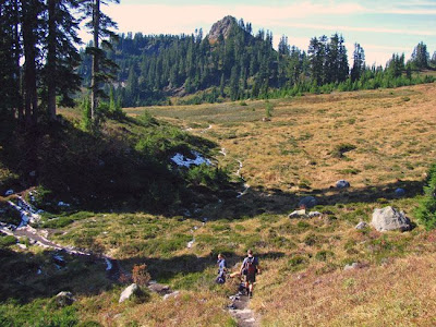
A point of the Black Buttes: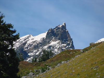
More of the Black Buttes (did you say "enough already"?)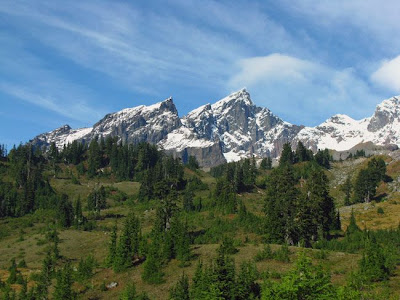
I'm really glad that my brother-in-law drove today because when we returned home we found that my car had a flat tire.
Thanks everyone for making this another enjoyable and memorable day in the North Cascades!
My next outing is scheduled for Saturday, November 15, 2008.
Friday, October 10, 2008
Prelim Plans for Sunday 10/12/08
The plans for the upcoming dayhike continue to change. With kids. Without kids. Not hiking at all.
Wait a minute - the forecast shows sunny skies?
Definitely going hiking.
Not sure if I have any buddies for the day or not (adult or kids... ) but feel free to contact me if you're interested.
Would like to head someplace new (like Yellow Aster Butte) but with the recent snow activity and solo, they'll probably have to wait until next year. If that's what it boils down to, then I may get the pleasure of visiting Railroad Grade or Park Butte on the south side of Mount Baker which is always an awesome destination. It doesn't seem possible that my last trip there was more than two years ago!
If the sunset on Sunday is as colorful as what we saw tonight then it would be worth staying late up at Park Butte for some fantastic photo opps before racing the darkness back to the car.
Planning to depart Mount Vernon at about 8:30am on Sunday.
Sunday, October 5, 2008
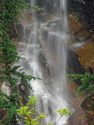
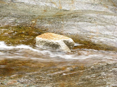
Denny Creek & Keekwulee Falls 10/5/08
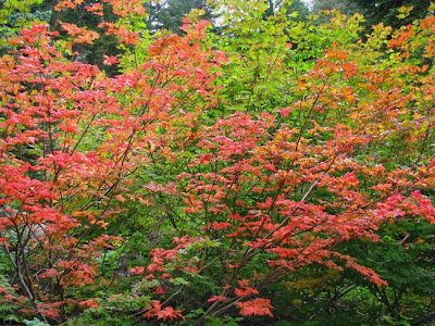
Today Rob, Steve and I enjoyed the scenery along Denny Creek - especially the view of Keekwulee Falls and the splash of fall color.
The trail was relatively quiet this morning, but on our return from the Hemlock Pass area we started to encounter more people. Still, there were quite a few less than I anticipated. Probably a combination of the season and the weather forecast. I hear this place is a zoo in the summer.
At the trailhead a crew was working to erect a new trailhead sign. Looks nice and strong.
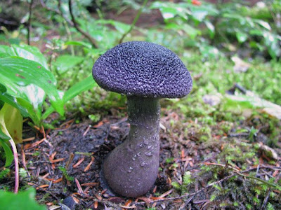
Before crossing under the I-90 elevated highway, 8buck observed this cool looking mushroom along the trail.
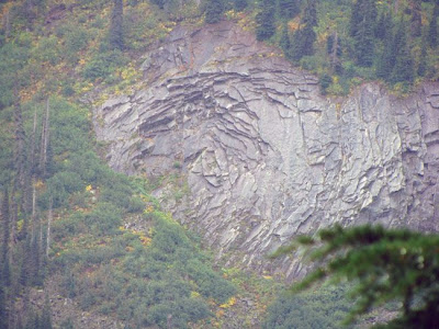
A while later we noticed this 'scaled' vertical cliff with a strange circular shape where the layers of rock have fallen out.
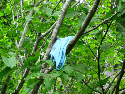
Met some friendly Robber Jays and found a blue tank top in a tree above the trail.
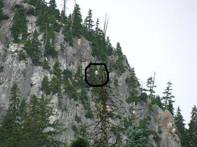
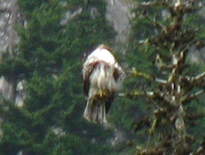
We also noticed a white spot in a distant tree across one of the talus slopes. Here is the original photo (full zoom) and then the photoshopped/cropped/enlarged 'white spot'. I figured it was an eagle, but it's in a peculiar postion - like it has its head under its wing.
Someday I'll head back out here and visit Lake Melakwa - when the weather is a little bit better.


The trail was relatively quiet this morning, but on our return from the Hemlock Pass area we started to encounter more people. Still, there were quite a few less than I anticipated. Probably a combination of the season and the weather forecast. I hear this place is a zoo in the summer.


At the trailhead a crew was working to erect a new trailhead sign. Looks nice and strong.
Before crossing under the I-90 elevated highway, 8buck observed this cool looking mushroom along the trail.

A while later we noticed this 'scaled' vertical cliff with a strange circular shape where the layers of rock have fallen out.

Met some friendly Robber Jays and found a blue tank top in a tree above the trail.


We also noticed a white spot in a distant tree across one of the talus slopes. Here is the original photo (full zoom) and then the photoshopped/cropped/enlarged 'white spot'. I figured it was an eagle, but it's in a peculiar postion - like it has its head under its wing.


Someday I'll head back out here and visit Lake Melakwa - when the weather is a little bit better.
Subscribe to:
Posts (Atom)